Tag Archives: GPS

GPS for ants (and maybe other animals, too)

Giant bulldog ant; GPS available as optional upgradeLike many naturalists, I’ve always been fairly fascinated by ants – their industrious sense of purpose, their ability to collaborate as a single metaorganism, and so on. Greater minds than myself have often wondered how they navigate over wide areas so effectively, and now an answer has been unearthed: ant antennae incorporate magnetic minerals that may form part of an insectoid GPS system. [image by Arthur Chapman]

“The incorporation of minerals probably starts as soon as ants start getting in touch with soil,” she added, explaining to Discovery News that her team found ultra fine-grained crystals of magnetic magnetite, maghemite, hematite, goethite, and aluminum silicates in ant antennae. These particles could make a “biological compass needle” that drives ant GPS.

[…]

Our planet is magnetized, likely due to rotational forces of liquid iron in Earth’s core. Although the resulting magnetic field is one-twenty thousandth as strong as a refrigerator magnet, ants appear to “perceive the geomagnetic information through a magnetic sensor (the dirt particles), transduce it in a signal to the nervous system and then to the brain,” she said.

Not all ants may use this particular system. Desert ants, for example, appear to have evolved special eyes that detect skylight polarization, which they then use to find their way around their sandy habitat. Magnetic particles, however, have been detected in many fish, birds, butterflies, flies, bees, bats, mole rats, newts, sea turtles and spiny lobsters, suggesting these animals find their way like the Brazilian ants do.

Ain’t nature wonderful?

I wonder if perhaps we humans have  a similar ability lying dormant in our bodies, shoved aside by evolutionary pressures as unnecessary since we stopped being roaming bands of primates and began to settle in stable locations. Perhaps it could be reawakened, or simply installed from scratch by some deft ribofunk biohacking? Imagine a post-fuel future where we have an entire and recently re-greened planet to roam on foot – how wonderful to set out with no map besides the tiny magnets buried in your brain!
GPS FAIL?

lost personGot a GPS in your car? Well, I hope you’ve not become too reliant on it and totally lost the ability to use old-fashioned road maps, because GPS service could start getting patchy next year, when the ageing satellites that make up the system’s infrastructure start falling out of orbit before their replacements can be set up.
Seems like someone’s been blowin’ the boondoggle blues and letting the maintenance schedule slip behind:

The warning centres on the network of GPS satellites that constantly orbit the planet and beam signals back to the ground that help pinpoint your position on the Earth’s surface.

The satellites are overseen by the US Air Force, which has maintained the GPS network since the early 1990s. According to a study by the US government accountability office (GAO), mismanagement and a lack of investment means that some of the crucial GPS satellites could begin to fail as early as next year.

“It is uncertain whether the Air Force will be able to acquire new satellites in time to maintain current GPS service without interruption,” said the report, presented to Congress. “If not, some military operations and some civilian users could be adversely affected.”

The report says that Air Force officials have failed to execute the necessary steps to keep the system running smoothly.

Ouch. As pointed out in the Guardian article, it’s highly unlikely that the USAF will let the system degrade totally – it’s too useful, not just to them but to a lot of people the world over – but just as we have to accept with other ubiquitous services like Google, outages may occur, and there’ll be no one to complain to; it’s all there in the small print, man. [image by Larsz]

That said, it’s a free market, and you can always shop around for alternatives – apparently Russia, China and India are all working on their own equivalent systems, which is probably even more upsetting to the USAF than the possibility of flakey service from their own kit.

Living la vida geo-loca

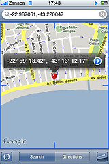
iPhone geo-locational software screenshotOver at Wired last week, they ran a piece by Matthew Honan about his experiences with the new wave of geolocational software for the iPhone and Google’s G1. He starts off by asking fellow users in his locality what they use the systems for:

My first response came from someone named Bridget, who, according to her profile, at least, was a 25 year-old woman with a proclivity for scarves. “To find sex, asshole,” she wrote.

“I’m sorry? You mean it’s for finding people to have sex with?” I zapped back.

“Yes, I use it for that,” she wrote. “It’s my birthday,” she added.

“Happy birthday,” I offered.

“Send me a nude pic for my birthday,” she replied.

A friendly offer, but I demurred. Anonymous geoshagging is not what I had in mind when I imagined what the GPS revolution could mean to me.

I don’t think anyone who has looked at the adoption curve for new networking technology will be particularly surprised by Bridget’s response… [image by zanaca]

Honan goes on to look at the pros and cons of what is admittedly still a technology in its applicational infancy, which he finds fun and intriguing at the same time that it seems creepy and intrusive – the latter response being one that I’d attribute to his age. When these apps have matured in a few years, however, the Facebook generation will have no qualms or fears about them whatsoever.

Whether they should have qualms is another question, of course. If nothing else, geolocational apps are a reminder that the tin-foil hat brigade’s warnings about The Feds being able to follow your cell phone weren’t entirely fictional; the potential for stalking someone is obvious.

But would stalking be as big a risk in a society where many people’s locations were public knowledge? If lifelogging catches on at the same time, we might all become one big happy globally geolocative panopticon…

Imagining the Adaptive City

In his writings on ‘cyborg urbanisation‘, Prof. Matthew Gandy (UCL) has compared the relationship between the city and its inhabitants with the cyborg – an archetype familiar to science fiction. For Gandy, the cyborg can help us understand the various networks that enable bodies to function in the modern city.

So, when Dan Hill (City of Sound) posted a vision of something he described as the Adaptive City, I was thinking of cyborgs … triggering a whole different set of neural pathways;

Facilitated by networks of sensors, the data emerging from the new [urban] nervous system appears limitless: near-imperceptible variations in air quality and water quality, innumerable patterns in public and private traffic, results of restaurant inspections, voting patterns in public referenda, triggers of motion sensors, the output of heating ventilation and air conditioning systems, patterns of water usage, levels of waste recycled, genres of books returned at local libraries, location of bicycles in the city’s bike-sharing network, fluctuations in retail stock controls systems, engine data from cars and aeroplanes, collective listening habits of music fans, presence of mobile phones in vehicles enabling floating car data, digital photos and videos locked to spatial co-ordinates, live feeds from CCTV cameras, quantities of solar power generated and used by networks of lamp-posts, structural engineering data from the building information models of newly constructed architecture, complex groupings of friends perceptible in social software multiplied by location-based services, and so on. Myriad flows of data move in and around the built fabric. As many or most objects in the city become potential nodes in a wider network … this shimmering informational field provides a view of the entire city.

But while science fictional tropes see the cyborg as defined either in terms of internal implants or some kind of powered exoskeleton (both dependent on the processes and contours of the individual body), Hill’s ‘Adaptive City’ externalises the cybernetic, projecting it outwards … into the environment; the physical landscape of which the organic body is but one among many. Perhaps the ‘Adaptive City’ is a decentralised cyborg … using feedback loops to harness the power of the collective, and watching its effects as …

[t]he invisible becomes visible … [and] the impact of people on their urban environment can be understood in real-time. Citizens turn off taps earlier, watching their water use patterns improve immediately. Buildings can share resources across differing peaks in their energy and resource loading. Road systems can funnel traffic via speed limits and traffic signals in order to route around congestion. Citizens take public transport rather than private where possible, as the real-time road pricing makes the true cost of private car usage quite evident. The presence of mates in a bar nearby alerts others to their proximity, irrespective of traditional spatial boundaries. Citizens can not only explore proposed designs for their environment, but now have a shared platform for proposing their own. They can plug in their own data sources, effectively hacking the model by augmenting or processing the feeds they’re concerned with.

(‘The Adaptive City’ has a companion piece, ‘The street as platform’ – also at City of Sound … image by taiyofj)

The secret life of shipping containers

shipping containers at VancouverNothing represents the ubiquity of global trade better than the humble metal shipping container, the industrial-scale use of which celebrates its fiftieth birthday this year.

The BBC, in one of their more adventurous and off-beat moments, have decided to crack the locks on containerised shipping with a year-long investigative project, prosaically entitled “The Box”. Basically, they’ve painted the BBC logo on a shipping container, fitted it with GPS, and set up an online map where you can follow its progress around the world over land and sea.

It’s not just a hollow gesture either – the container will actually be used for carrying real cargoes, so we’ll get to watch world trade in action. That said, it might be a bit more exciting to watch in high speed once the project is over…

All I want to know now is which bright spark at the Beeb has been reading Spook Country? [hat-tip to Asgrim; image by sporkist]