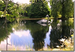
 Even though analyzing high-resolution satellite imagery (with the help of Amazon’s Mechanical Turk) hasn’t turned up the missing adventurer Steve Fossett, it did discover several previously unknown small crashed planes, some dating back to the 1950s. So why not put it to even more productive use, asks columnist Benjamin Radford, and use it to find Bigfoot or one of the various lake monsters said to inhabit Scotland’s Loch Ness, Canada’s Lake Okanagan or the U.S.’s Lake Champlain, among others? [Via LiveScience.]
Success would convince the skeptics, while failure would do nothing to dissuade the True Believers. So it’s win-win all around! [Image: Wikimedia Commons.]
[tags]cryptozoology, satellite imagery, monsters[/tags]
New technologies have a tendency to develop unintended side effects, for both good or ill–just look at how automobiles changed society. Satellite imaging gave us better weather forecasts and more accurate military surveillance–and now, stronger sales leads for home contractors!
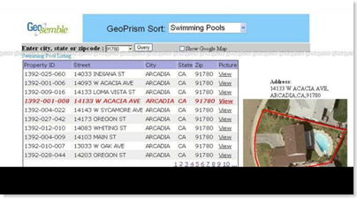
A company called Geosemble is using artificial intelligence combined with satellite imagery to direct companies toward local residents whose houses and grounds are in need of repair. The National Science Foundation in the U.S. has given them a Phase I grant to further develop the process.
Now if you’ll excuse me, I think I’ll go wrap my house in aluminum foil.
(Via Gizmag.)
(Photo from Gizmag, too.)
[tags]satellite, satellite imagery, privacy[/tags]
Presenting the fact and fiction of tomorrow since 2001
 Even though analyzing high-resolution satellite imagery (with the help of Amazon’s Mechanical Turk) hasn’t turned up the missing adventurer Steve Fossett, it did discover several previously unknown small crashed planes, some dating back to the 1950s. So why not put it to even more productive use, asks columnist Benjamin Radford, and use it to find Bigfoot or one of the various lake monsters said to inhabit Scotland’s Loch Ness, Canada’s Lake Okanagan or the U.S.’s Lake Champlain, among others? [Via LiveScience.]